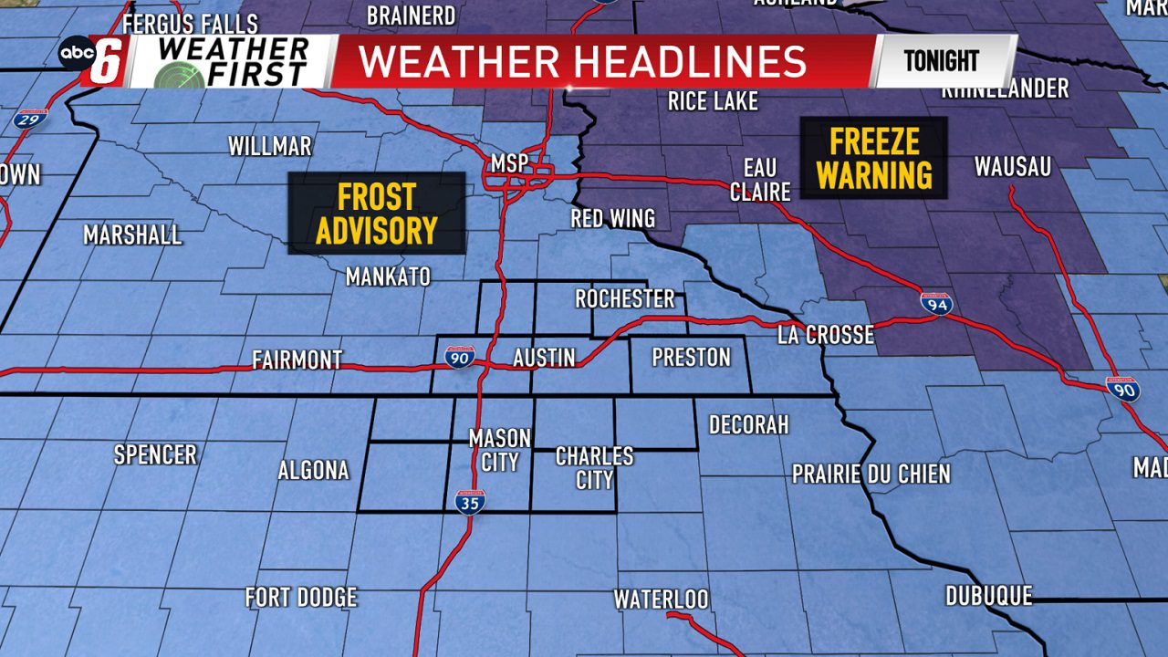
Frost advisory in effect into Wednesday morning
Blizzard Warning (IA)
Issued: 2025-03-19 5:00 AM
Severity: Extreme | Urgency: Expected | Certainty: Likely
Areas Affected: Emmet; Kossuth; Winnebago; Worth; Palo Alto; Hancock; Cerro Gordo; Pocahontas; Humboldt; Wright; Franklin; Sac; Calhoun; Webster; Hamilton; Crawford; Carroll; Greene; Audubon
...BLIZZARD CONDITIONS EXPECTED WEDNESDAY... .The combination of moderate to heavy snow and strong, gusty winds are forecast to produce blizzard conditions Wednesday in the warning area. Two inch per hour snowfall rates will be possible along with thundersnow. Strong and damaging wind gusts are also possible. Travel may be difficult to impossible at times.
WHAT...Blizzard conditions expected. Total snow and sleet accumulations between 2 and 10 inches. Winds gusting as high as 60 mph. Lowest amounts on the southeast edge of the Blizzard Warning.
WHERE...Portions of west central, north central, and central Iowa.
WHEN...From 5 AM to 10 PM CDT Wednesday.
IMPACTS...Travel could be very difficult. The hazardous conditions could impact the Wednesday morning and evening commutes. Strong winds could cause tree damage.
Blizzard Warning (MN)
Issued: 2025-03-19 5:00 AM
Severity: Extreme | Urgency: Expected | Certainty: Likely
Areas Affected: Waseca; Steele; Martin; Faribault; Freeborn
...HEAVIEST SNOW SHIFTING SOUTH WITH WINTER STORM... .The narrow band of heavier snow has shifted south, and the gradient has tightened up. As a result, areas across central Minnesota will see less snow, so the Blizzard Warning was replaced with a Winter Weather Advisory for Le Sueur, Nicollet, Brown, Watonwan, Rice, and Goodhue counties. Areas to the south and east of those counties have a higher chance of seeing whiteout conditions from heavy snow and strong wind, so a blizzard warning remains in effect for those locations. In Pepin and Eau Claire Counties, a Winter Storm Warning remains in effect. As for timing, snowfall rates of 1 to 2 inches per hour will develop Wednesday morning and last into early Wednesday afternoon. Northwest winds of 30 to 40 mph will accompany the snow, with occasional gusts near 45 mph along I-90.
WHAT...Blizzard conditions expected. Total snow accumulations between 5 and 8 inches and north winds gusting 35 to 45 mph.
WHERE...Faribault, Freeborn, Martin, Steele, and Waseca Counties.
WHEN...From 5 AM to 7 PM CDT Wednesday.
IMPACTS...Whiteout conditions are expected and will make travel treacherous and potentially life-threatening. Travel could be very difficult. Widespread blowing snow could significantly reduce visibility. The hazardous conditions could impact the Wednesday morning and evening commutes. Gusty winds could bring down tree branches.
Blizzard Warning (MN)
Issued: 2025-03-19 7:00 AM
Severity: Extreme | Urgency: Expected | Certainty: Likely
Areas Affected: Mitchell; Dodge; Olmsted; Mower; Fillmore
...IMPACTFUL WINTER STORM WEDNESDAY... .A narrow band of heavy, wet snow and very strong winds will accompany a late winter storm for Wednesday. Currently, the band looks to primarily impact portion of southeast Minnesota into north central Wisconsin with 8 plus inches. In addition, strong north winds will gust from 35 to 55 mph. When coupled with the heaviest snow rates, white out to near white out conditions could be realized.
WHAT...Blizzard conditions expected. Total snow and sleet accumulations between 4 and 9 inches and ice accumulations around a light glaze. Winds gusting as high as 55 mph.
WHERE...In Iowa, Mitchell County. In Minnesota, Dodge, Fillmore, Mower, and Olmsted Counties.
WHEN...From 7 AM to 7 PM CDT Wednesday.
IMPACTS...Travel could be very difficult. Widespread blowing snow could significantly reduce visibility. The hazardous conditions could impact the Wednesday morning and evening commutes. Strong winds could cause tree damage.
High Wind Warning (IA)
Issued: 2025-03-19 7:00 AM
Severity: Severe | Urgency: Expected | Certainty: Likely
Areas Affected: Emmet; Kossuth; Winnebago; Worth; Palo Alto; Hancock; Cerro Gordo; Pocahontas; Humboldt; Wright; Sac; Calhoun; Webster; Crawford; Carroll; Greene; Audubon; Guthrie; Cass
WHAT...North winds 30 to 40 mph with gusts up to 65 mph expected.
WHERE...Portions of west central to north central Iowa.
WHEN...From 7 AM to 7 PM CDT Wednesday.
IMPACTS...Damaging winds will blow down trees and power lines. Some power outages are expected. Travel will be difficult, especially for high profile vehicles.
Winter Storm Watch (IA)
Issued: 2025-03-19 7:00 AM
Severity: Severe | Urgency: Past | Certainty: Observed
Areas Affected: Butler; Hardin; Boone; Guthrie; Cass
The Winter Storm Watch has been replaced. Please see the latest information from NWS Des Moines IA on this developing situation.
High Wind Warning (IA)
Issued: 2025-03-19 1:00 PM
Severity: Severe | Urgency: Expected | Certainty: Likely
Areas Affected: Franklin; Butler; Bremer; Hamilton; Hardin; Grundy; Black Hawk; Boone; Story; Marshall; Tama; Dallas; Polk; Jasper; Poweshiek; Adair; Madison; Warren; Marion; Adams; Union; Clarke; Lucas; Taylor; Ringgold; Decatur; Wayne
WHAT...North winds 30 to 40 mph with gusts up to 60 mph expected.
WHERE...Portions of central Iowa.
WHEN...From 1 PM to 10 PM CDT Wednesday.
IMPACTS...Damaging winds will blow down trees and power lines. Some power outages are expected. Travel will be difficult, especially for high profile vehicles.
Winter Storm Warning (MN)
Issued: 2025-03-19 7:00 AM
Severity: Severe | Urgency: Expected | Certainty: Likely
Areas Affected: Winona; Taylor; Clark; Buffalo; Trempealeau; Jackson
...IMPACTFUL WINTER STORM WEDNESDAY... .A narrow band of heavy, wet snow and very strong winds will accompany a late winter storm for Wednesday. Currently, the band looks to primarily impact portion of southeast Minnesota into north central Wisconsin with 8 plus inches. In addition, strong north winds will gust from 35 to 55 mph. When coupled with the heaviest snow rates, white out to near white out conditions could be realized.
WHAT...Heavy snow expected. Total snow accumulations between 4 and 7 inches. Winds gusting from 35 to 45 mph.
WHERE...Portions of southeast Minnesota and central, north central, and west central Wisconsin.
WHEN...From 7 AM to 7 PM CDT Wednesday.
IMPACTS...Travel could be very difficult. Widespread blowing snow could significantly reduce visibility. The hazardous conditions could impact the Wednesday morning and evening commutes.
Winter Weather Advisory (IA)
Issued: 2025-03-19 7:00 AM
Severity: Moderate | Urgency: Expected | Certainty: Likely
Areas Affected: Winneshiek; Houston; La Crosse; Monroe
...IMPACTFUL WINTER STORM WEDNESDAY... .A narrow band of heavy, wet snow and very strong winds will accompany a late winter storm for Wednesday. Currently, the band looks to primarily impact portion of southeast Minnesota into north central Wisconsin with 8 plus inches. In addition, strong north winds will gust from 35 to 55 mph. When coupled with the heaviest snow rates, white out to near white out conditions could be realized.
WHAT...Wet snow expected. Total snow and sleet accumulations between 1 and 3 inches. Winds gusting from 35 to 45 mph.
WHERE...In Iowa, Winneshiek County. In Minnesota, Houston County. In Wisconsin, La Crosse and Monroe Counties.
WHEN...From 7 AM to 7 PM CDT Wednesday.
IMPACTS...Plan on slippery road conditions. Areas of blowing snow could significantly reduce visibility. The hazardous conditions could impact the Wednesday morning and evening commutes. Gusty winds could bring down tree branches.
Winter Weather Advisory (IA)
Issued: 2025-03-19 7:00 AM
Severity: Moderate | Urgency: Expected | Certainty: Likely
Areas Affected: Howard; Floyd
...IMPACTFUL WINTER STORM WEDNESDAY... .A narrow band of heavy, wet snow and very strong winds will accompany a late winter storm for Wednesday. Currently, the band looks to primarily impact portion of southeast Minnesota into north central Wisconsin with 8 plus inches. In addition, strong north winds will gust from 35 to 55 mph. When coupled with the heaviest snow rates, white out to near white out conditions could be realized.
WHAT...Snow expected. Total snow and sleet accumulations between 2 and 4 inches. Winds gusting from 45 to 55 mph.
WHERE...Floyd and Howard Counties.
WHEN...From 7 AM to 7 PM CDT Wednesday.
IMPACTS...Plan on slippery road conditions. Widespread blowing snow could significantly reduce visibility. The hazardous conditions could impact the Wednesday morning and evening commutes. Strong winds could cause tree damage.
Wind Advisory (IA)
Issued: 2025-03-19 1:00 PM
Severity: Moderate | Urgency: Expected | Certainty: Likely
Areas Affected: Chickasaw; Fayette; Clayton
WHAT...North winds 25 to 35 mph with gusts up to 55 mph expected.
WHERE...Chickasaw, Clayton, and Fayette Counties.
WHEN...From 1 PM to 7 PM CDT Wednesday.
IMPACTS...Gusty winds will blow around unsecured objects. Tree limbs could be blown down and a few power outages may result.
Winter Weather Advisory (IA)
Issued: 2025-03-19 7:00 AM
Severity: Moderate | Urgency: Expected | Certainty: Likely
Areas Affected: Butler; Hardin; Boone; Guthrie; Cass
...BLIZZARD CONDITIONS EXPECTED WEDNESDAY... .The combination of moderate to heavy snow and strong, gusty winds are forecast to produce blizzard conditions Wednesday in the warning area. Two inch per hour snowfall rates will be possible along with thundersnow. Strong and damaging wind gusts are also possible. Travel may be difficult to impossible at times.
WHAT...Snow expected. Total snow and sleet accumulations up to 3 inches. Winds gusting as high as 60 mph.
WHERE...Boone, Hardin, Butler, Cass, and Guthrie Counties.
WHEN...From 7 AM to 10 PM CDT Wednesday.
IMPACTS...Plan on slippery road conditions. The hazardous conditions could impact the Wednesday morning and evening commutes. Strong winds could cause tree damage. The strong winds and falling snow may produce brief periods of near whiteout conditions.
Winter Weather Advisory (MN)
Issued: 2025-03-19 7:00 AM
Severity: Moderate | Urgency: Expected | Certainty: Likely
Areas Affected: Scott; Dakota; Rice; Goodhue; Rusk; Pierce; Dunn; Chippewa
...HEAVIEST SNOW SHIFTING SOUTH WITH WINTER STORM... .The narrow band of heavier snow has shifted south, and the gradient has tightened up. As a result, areas across central Minnesota will see less snow, so the Blizzard Warning was replaced with a Winter Weather Advisory for Le Sueur, Nicollet, Brown, Watonwan, Rice, and Goodhue counties. Areas to the south and east of those counties have a higher chance of seeing whiteout conditions from heavy snow and strong wind, so a blizzard warning remains in effect for those locations. In Pepin and Eau Claire Counties, a Winter Storm Warning remains in effect. As for timing, snowfall rates of 1 to 2 inches per hour will develop Wednesday morning and last into early Wednesday afternoon. Northwest winds of 30 to 40 mph will accompany the snow, with occasional gusts near 45 mph along I-90.
WHAT...Snow and blowing snow expected. Total snow accumulations between 1 and 4 inches. Winds gusting as high as 40 mph.
WHERE...In Minnesota, Dakota, Scott, Rice, and Goodhue Counties. In Wisconsin, Rusk, Chippewa, Dunn, and Pierce Counties.
WHEN...From 7 AM to 7 PM CDT Wednesday.
IMPACTS...Travel could be very difficult. The hazardous conditions could impact the Wednesday morning and evening commutes.
Winter Weather Advisory (MN)
Issued: 2025-03-19 4:00 AM
Severity: Moderate | Urgency: Expected | Certainty: Likely
Areas Affected: Brown; Nicollet; Le Sueur; Watonwan; Blue Earth
...HEAVIEST SNOW SHIFTING SOUTH WITH WINTER STORM... .The narrow band of heavier snow has shifted south, and the gradient has tightened up. As a result, areas across central Minnesota will see less snow, so the Blizzard Warning was replaced with a Winter Weather Advisory for Le Sueur, Nicollet, Brown, Watonwan, Rice, and Goodhue counties. Areas to the south and east of those counties have a higher chance of seeing whiteout conditions from heavy snow and strong wind, so a blizzard warning remains in effect for those locations. In Pepin and Eau Claire Counties, a Winter Storm Warning remains in effect. As for timing, snowfall rates of 1 to 2 inches per hour will develop Wednesday morning and last into early Wednesday afternoon. Northwest winds of 30 to 40 mph will accompany the snow, with occasional gusts near 45 mph along I-90.
WHAT...Snow and blowing snow expected. Total snow accumulations between 2 and 5 inches. Winds gusting as high as 40 to 45 mph.
WHERE...Blue Earth, Brown, Le Sueur, Nicollet, and Watonwan Counties.
WHEN...From 4 AM to 7 PM CDT Wednesday.
IMPACTS...Plan on slippery road conditions. The hazardous conditions could impact the Wednesday morning and evening commutes. Gusty winds could bring down tree branches.
Winter Storm Watch (IA)
Issued: 2025-03-19 7:00 AM
Severity: Minor | Urgency: Past | Certainty: Observed
Areas Affected: Bremer
The Winter Storm Watch has been cancelled and is no longer in effect.